Saturday, 27 June 2015

Gold, greed, and ages past

A long stretch north then to Charters Towers, hundreds of kilometres to drive. We overnighted in a place called Belyando Crossing which has a population of five, all of whom serviced the petrol station, store, motel, campground and tourist information centre that operated there. The straight drive was a slow playing video of mean-eyed crows, swollen carrion, deeply cratered and dried out creek beds, and burnt eucalypts, with beef cattle sporadically bunched around feed bins, until we turned into ‘The Towers’ as it is affectionately known.

Charters Towers had its beginnings in 1871, when a young aboriginal boy, Jupiter Mossman, tripped over a lump of quartz, glistening after rain. Gold. And plenty of it. Thousands of miners soon invaded the area, throwing down their tents and tools and staking out a claim under the natural rocky tor that rises up out of the earth, which contributed to the ‘Towers’ in the name of the place.

Mines were pegged, gold lumps soon filled the drays and wheelbarrows that rattled down the dusty tracks that were to become the town streets. Vast fortunes were made. This was no ordinary gold find. Discoveries were stretching on, and on. The burghers, trying to keep law, order and a sense of community about the place, made decisions then, which today, leave Charters Towers a gem of a town for tourists to visit: one decision was that buildings fronting the main streets were to be of stone.

And so they were built. One being the extraordinary arched arcade at the top of town which turned into the stock exchange where ‘calls’ were made three times a day at the height of the boom. The arcade would often hold a thousand investors, bidders and onlookers enthralled, as small clumps of rock tinged with gold were sold off as shares to investors all over the world as miners sought capital to go deeper, wider, richer. Close to the Stock Exchange Arcade is the Australian Bank of Commerce: elegant and beautiful in its carved stone finery.

There followed the telegraph and post office building, the police station, mens clubs, gaming rooms, hotels, and more hotels; glass fronted shops with pressed metal ceilings and art deco facades, gorgeous fashionable homes for rich mine owners--as the gold kept on coming.

While all around were dusty streets filled with claim jumpers trying to muscle in, attempting any route to easy riches, so murder and mayhem were rampant in the dozens upon dozens of public houses set up right on top of the goldfields. All activities overlaid by the constant earth-throbbing noise from dozens of batteries ramming tons of lumpen rock all over town—so loud the thump could be heard for kilometres. And furtive silent killers took their deadly toll, as the town’s creek water was topped up with the massive doses of chemicals needed daily to extract the precious gold: cyanide and mercury: killers both. Miners desperately needed the water, but were literally going mad using it.

And, of course, the boom didn’t last. After twenty-five golden years, it shuddered, unwillingly, to a very slow death, the last battery finally closing in 1973--the tunnels under the town gradually filling with water.

Today, tourists are the town’s gold as there are ghost and gold tales aplenty to keep them coming here forever. The town fills with travellers most days of the year.

All is not lost underground, either. Technology has moved on. There have been new fields pegged out and new efficient ways to mine the gold worked out. And if all predictions are correct there is said to be more gold still to extract from the earth directly beneath Charters Towers than has been taken in the dozens of decades that have gone before. Future tales to tell.


Burnt and dried out


Parked at the top of town in Charters Towers 


Stock Exchange Arcade designed by a Melbourne architect 


Australian Bank of Commerce


Glass fronted shops 


Art deco advertising in glass


Exquisite ironwork on the storefront 


Thornborough, a battery owner's home; now part of a boarding school 


This beautiful home once serviced 15, 000 American servicemen
as a hospital during the war 


Tourists need this sign near the battery


Tales of old Bogantungan

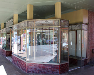
Emerald’s main street is lined with massive Moreton Bay Fig trees once pruned by feral goats who were allowed to wander freely in the streets decades ago, so the trees are thick and flourishing as a result. 

After a quick coffee in their shade, we headed further west where the sides of the road are becoming more and more rust red, replicated in the corroded signs the shire has made as a welcome to each town throughout the region. So very Australian. 

This digging sign is for Anakie, which became the centre for gem exploration around these parts after an 1870 explorer picked up stone he thought might be ruby, but which turned out to be zircon.

In modern times, a young 14 year old boy, Smiley Nelson, was much luckier. In 1979, while specking wet rock he picked up what turned out to be the largest yellow sapphire ever found anywhere — over 13 ounces. He sold it to the Richardson brothers of Sapphire, but along with other gems on display in Sydney in 1983, it was stolen in a massive $8 million jewellery heist. Luckily it was found again, quite accidentally, three years later, and the stone rescued; only to be sold shortly afterwards to an American for a massive sum, it is said. 

On to Bogantungen we drove, intent on catching up on a little family history while we were in this region as some of Pete’s family once had a cattle property there. After Anakie, the roads become narrower, the vegetation sparser; though, thankfully, the trucks and ute traffic dropped dramatically after Blackwater, and to a lesser extent, Emerald. 

Only two very old men live in two very old houses in all that is left of Bogantungan. Once 28 pubs were needed to cater to the thirsty locals here, when much of the work that kept them in pocket stemmed from railway business. Today, the railway station is a dusty little building, a museum itself, as it is quite a rare example of an early Australian platform station. It houses a dusty collection of fading memorabilia and newspaper cuttings donated by locals over the years: tales of old Bogantungan.

One display tells of one of the worst train disasters in Australia’s history. Here, on a night in 1969 after heavy rains, a 12 ton tree fell and floated downstream until it crashed into a pier of the railway bridge, weakening the structure, so that when the 2am train loaded with passengers hurtled across the bridge the weight gave out. Forward propulsion was sufficient to allow the front carriages to reach safety on the opposite bank but once the bridge started to fail, the back carriages tumbled headlong into the creek, killing seven, wounding many others. Tales of heroism and great effort of that night have been proudly thumb-tacked to tired walls. 

We found burial records for Pete’s family in a booklet in the museum that one of the locals had once thoughtfully compiled. We then headed out to the old property, Medway Park, where cattle still graze on grasslands: very dry now, and very isolated. Our last stop was to the old town cemetery, where we found some of the family headstones still standing, their inscriptions barely visible. Others have crumbled and been lost. We also learned that one family member is still alive, retired to Yeppoon, though a great age, so a few more leaves on the family tree have been added as a result of our visit. 

Bogantungan is as far west as we travel this trip, so we turn back to Anakie and take a shortcut, past Sapphire and Rubyvale in the gem fields, heading north. These fossicking towns look a lot like a Footrot Flats version of Coober Pedy, with their assortment of shacks, crooked caravans, corrugated iron huts, and ramshackle dwellings huddled around hillocks of dug over dirt, offering every conceivable item a visiting fossicker might want: a museum; a shovel; a lesson in how to fossick; a gem to buy, a coffee to drink. So colourful and eccentric much of it made us laugh. 

We followed the road from Rubyvale to Clermont which turned out to be one of those iconic Australian roads that are a joy to drive: just us, grazing beef cattle, and cattle grids rippling across the road every so many kilometres, stretching as far as the road goes, tableland grasses on all sides, mountains like tiny volcanoes set low on the horizon.

Just a few kilometres along we saw our first massive wedge-tailed eagle of this trip: deeply intent on his kill in the middle of the road. As we closed in, he had to make a giant physical effort to leave his prey, and flapped labouriously with a slow, lumbering beat of huge outstretched wings, his body barely gaining van height as we passed: so close, we could see his beautifully curved wedge tail as he retreated to safety. 

As the afternoon sun set lower, kangaroos ventured out on to the quiet road, only to baulk when they saw us, ducking quickly back under the cover of shrubs, trees and grasses. 

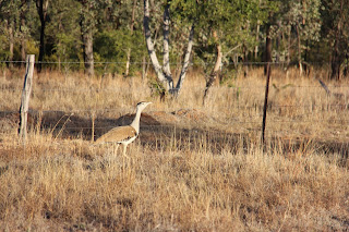
Three Australian Bustards froze along one of the perimeter fences, their colouring almost invisible against the camouflage of the speckled gum tree trunks. As we moved closer to take a photo they flapped and flew off.

Finally, we spied an elegant Eastern Great Egret fishing for its evening meal; its bill poised like a spear while standing precariously on an arched twig in one of the rare watered creek beds at the road side.

A wonderful end to a special day for Miss Bec’s birthday. Not France this year for her, which it has been for many years, but something a little closer to home. 

Albeit there is a strong French connection, as Clermont, we later discovered, was named after Clermont-Ferrand in France, a place we have visited often, which turned out to be the ancestral home of Oscar de Satge, the French fellow who took up the very first run in this area, and named the place. Though, we tend to flavour the name with more of an Aussie twang than Oscar might have used.


Downtown Emerald -- dressed in green 


Anakie in rust

.   

Historic Boguntungan


Once there was a bridge


At rest 


Fabulous road to Clermont


Australian bustard


Eastern Great Egret


Our lunch spot in Clermont the next day


Tuesday, 23 June 2015

Dongas and dig trees

Mines were prevalent the next day, too. Mine traffic was everywhere the further west we moved: trucks, utes and work vehicles are heavy on the suffering roads; and coal trains, often loaded with a hundred coal wagons, apiece, are busy riding the rails beside the road.  We saw five massive rail shipments in just one morning.  On tracks that are being renewed, and strengthened, we imagine.  

Yet at Blackwater, which appeared to us virtually a purpose-built mine town, one of the local farmers from Dingo told us that the mining down turn is biting hard at the community. Added to which the drive-in-drive-out and FIFO mine worker philosophy utilised by the mines did little to benefit the town, he argued. Donga-type resorts were clustered in many parts of town, all serviced and efficient, and single men tended to stay in the area for their shift only; their families living elsewhere.  So, schools, shops, and the community suffered under those sorts of pressures, he said.  

Though I can’t say it looked as if it was doing it too tough to us, at the moment.  We thought it busy and bustling; but then we don’t have the perspective of time to see the difference.  

We stopped for a break in a little park in the village of Comet only to find that Ludwig Leichhardt had been here before us.  In fact, he named the place after seeing a comet while here, on one of his trips in the 1840s.    He also left a DIG tree, which really surprised us, as while we are familiar with the term ‘DIG tree’ we had heard it, previously, only in relation to Burke and Wills’s tragic expedition and had no idea that it was standard practice for early explorers to leave a cache of food and journals under a tree marked with the word: DIG.  As Leichhardt did.   Leichhardt’s original DIG sign is on a tree trunk cut and caged in wire, the etching so old it is barely visible.  For clarity,  we took a shot of what it would have looked like new.  

Then we learned another amazing piece of Aussie history: Ludwig Leichhardt discovered coal around these parts.  

We were left to wonder: had Leichhardt been able to look ahead nearly two hundred years, at the polluted waters around these shires, at the roads and rails creaking under the weight of digging out and transporting this black gold, at these strange donga-communities that have sprouted hereabouts,  would he have made the effort to bend down and pick up that first piece of black coal, given what would eventuate?

We ended up chatting, very fortuitously, to an auto-electrician parked in a pullout in Emerald where we happened to be map reading.  Luckily, he had his tools on tap, and after a question or three, he popped in to test our inverter and batteries and clarified much about our solar, inverter and batteries system that we did not understand.  We now know what to do with some of the switches in our rig that we had no clue about before.   A brilliant encounter. 

We then hunted down a quite campground in the back of Emerald for the night, away from the trucks, trains and bustle of the town and, again, found fruit pickers from many countries and creeds.  Mandarins are being picked at the moment, grapes in about three weeks, we were told.  We were surprised as we had seen no such crops from the road. We were even offered guided visits to see the fruit plantations in action. The hospitality out here is amazing.  

We were told by some of the staff that a group of the Tongan fruit-pickers here aim to save $10,000 AUD a year from each nine month contract, hoping to take that back home during their break period.  A great goal, though it still means families living apart in order to survive.  

Leichhardt left a dig sign much like this


White and yellow corellas; black and red cockatoos

We are trying a new routine this trip — taking a day a week off from driving, and Cania Gorge was exactly the spot to pause for that. There were walks in every direction starting at the campground and lots of happy campers enjoying this mini-Carnarvon. A massive flock of corellas, our first sighting this trip, wheeled in the sky as we left the gorge on Monday morning, then settled, gracefully, on to three dead gums around a waterhole. So typically Australian, yet I missed photographing it. There were so many of them that they turned the gum tree white.

Motorhome and caravans are starting to appear and there were so many that they literally circled the perimeter of Biloela by lunch time, like a posse on a hunt. It must have been rather like this, historically, when the runs around here were carved up into selections: buyers would have been swooping in goodly numbers, biting their nails until their number was called. 

As we drove on we saw that much of the land has been given over to a crop we haven’t seen before: a tall spindly bush with a cluster of pea pods on top, sometimes planted all over the paddock, at other times planted in rows: quite ugly when it is dried out, and not all that pretty when it is young and green. So, as is our want, we stopped and asked a farmer about it and discovered it is Leucaena, a fast growing legume used as feed for cattle. 

Our informer was not a fan. It regrows when cut, and its pods fly everywhere, so it fast becomes an invasive weed if not properly cared for, he said. After that, we saw it everywhere: on sides of roads, deep in creek gullies. We even saw signs put up by others, disenchanted with it, who advertised that they had the right equipment to root it out of the ground forever. If you wanted it gone. There is no doubt, though, cattle appear to love eating it. But it is odd to watch them as they tend to want to stretch so high for the nutritious green bits that they look like giraffes arching long necks to wind their tongue around the tops of tallest, greenest, bushiest part. So the plant offers bonus neck exercise, too, though I wonder if that is a plus: if it makes that part of the beast more tender as a result. 

Still, there are hills on all sides: lovely. This area we are now in is called the Central Highlands, the route, Australia’s Country Way. There is still that flush of green to the grasses as we drive further west and in parts the trees become more stunted and as the land starts to look a lot like South Africa I expect elephants to pop up from behind bushes and lions to peer over the grasses. But, no. There are sparse fields of healthy looking cattle only in these parts. 

Then, around Dululu and the River Dee, birds. In a tall patch of trees lining the river we saw a small flock of stunning red-tailed black cockatoos, and the bright turquoise of a sacred kingfisher sitting on a dead branch near the river waiting for a fish to pop into its mouth. After coming to a screeching halt in the motorhome, we walked a long way back to get photographs, but missed them both. 

The railway grass was glowing pink on the side of the road as we headed to our camping spot between the cemetery and the waterhole at Duaringa — a peaceful stopover for the night. Along with dozens of others. Campgrounds seem to have lost favour with many of the travelling public, and many local towns offer public amenities, encouraging their stay. This one is well favoured. Before supper we had time for a visit to the historical cemetery and many of the headstones were of settlers from early in the 1800s, the names repeated again and again as families stayed on in the region. Over to the waterhole, then, which was circled by a good stand of stringy bark trees, used by local indigenous folk to make their ropes and baskets. Sadly, the waterhole and the creeks around here, bear notices that the water is polluted: mine waste. So, it is not all roses.

Tropical vegetation at Cania Gorge


Posse of camping rigs at Biloela


 Leucaena


Duaringa Stringy Bark 


Sunday, 21 June 2015

Lungfish breathing, bunyips bubbling

After a delightful couple of days in the lush green sugar cane country of Bundaberg and its surrounds visiting friends in beautiful Bargara and discovering interesting new pieces of our family history jigsaw puzzle, we headed inland: our favourite place to be in Australia. 

This is the hot damper part of the blog title. Inland we go and immediately long for hot damper cooked over burning coals. We aim to have some. 

The town of Gayndah makes us think of oranges, but there are not so many orange trees near the road these days after a killer citrus disease swept through the region not so long ago, wiping out a lot of plantations. Here, though, they are still growing big oranges, though they might become more famous for making really terrible coffee. Our morning coffee was dire. 

Amazingly, after early exploration Gayndah was one of the first settled areas in Queensland, and one of the earliest towns. It vied with Ipswich in an attempt to become Queensland’s capital at one stage, but lost out because its river was too shallow to support the shipping that would have been needed by a capital city. 

Its very shallow river, the Burnett, is home too, to a really odd fish: the lungfish: native only to the Burnett and Mary Rivers. When left high and dry on a shallow sandbank as river waters recede on a regular basis, the fish is able to breathe like a human, using its lungs. An oddity of evolution in action. 

The hills surround us as we head inland, and the grass-covered plains roll on endlessly. We enter whistling kite territory as we drive towards Munduberra They are wheeling and circling overhead, their distinctive white M markings flashing underwing as we drive. Not many, though. 

Munduberra calls itself the citrus capital of Queensland, and regularly vies with Gayndah in a “State of Oranges“ rugby playoff to see who should really wear that guernsey. It is all fruit and fruit-picking hereabouts and as we attempt to hunt down a better coffee we notice a large number of young people around the small town centre, walking, chatting, playing on their mobiles, or simply resting. Backpackers, we assume: Japanese, Tongan, Papua New Guineans. Probably on a well-deserved day off. Then we learn that they are likely part of the Pacific Seasonal Worker’s Scheme, piloted a few years ago and now well established, which caters to workers who are prepared to take on seasonal work in rural and remote locations in Queensland. They bring a vibrancy to the town, and the caravan parks are busy so that must be an added bonus for the place. 

We spent a lovely afternoon at the newish R M Williams Bush Learning Centre just as you enter Eidsvold. The Centre has been set up in this well maintained inland town by the shire and the Williams family as a tribute to R M who lived hereabouts. 

The staff at the centre organise bush craft days and activities: including leather work, saddlery, wood and stone work, and offers meeting rooms for local clubs, along with camping spaces for the visiting public on its well kept grounds. It has a small yet perfectly formed information room with displays and videos on the life and times of R M. There is also a big gallery, which, when we were there was exhibiting aboriginal art and craftwork. I can see this entire complex being a big drawcard for this tiny outback town and the friendly service offered by the staff was second to none. A wonderful welcome to Eidsvold and the centre. 

We called in at Mulgildie, the home of the swamp bunyip. At a waterhole just west of town strange things go bubble and bump in the night. So much so that over the years aboriginals and stockmen have refused to stop there. Terrified. According to aboriginal lore that mythical monster, the bunyip, can swallow huge beasts whole. It is best avoided. 

The grass in the paddocks enroute to Cania Gorge glows silver in the setting sun. There has been recent rain and there are puddles still on the side of the road. Well-watered beef cattle dotting the paddocks munch a grassy supper as daylight gives way to early evening.

Citrus packing case labels


Look out for lungfish on the sandbanks


R M Williams Bush Learning Centre


Excellent logo


Worn packhorse saddle on display


The Mulgildie Bunyip 


Characters, cream and horny ends

Still grumpy at government the next morning, we decided to head across to take a look at the Mary River valley which was once almost drowned as the site of the controversial Traviston dam. The predictive text on my computer keeps trying to write ‘travesty’ for Traviston. I should let it. It is simpatico. 

In another botched decision state government paid out hundreds of Mary River farmers to quit their land in this quiet valley, so that a dam could be built at a time when water was much needed throughout the state due to drought. Nothing wrong conceptually with the thinking. Water has to come from somewhere, and in drought times we must have supply. All very real. But local residents could make no sense of the solution the government came up with. Just a kite’s flight away was a dam, already in existence. All it needed to store all the water the Mary valley could offer was a raised wall. Moreover, it was on land the government already owned. No expensive payouts were needed. Problem solved, they argued. 

But no. The state government quickly processed the land resumption notices, paid the farmers a mighty compensation settlement, and acquired hundreds of acres of Mary River land to flood. But, just at the pointy end of all that decision-making and expenditure, the federal government stepped in—no doubt thinking of their re-election chances—and put the kibosh on the state plan, declaring the site should not, would not, a dam make. 

Red-faced and severely short-in-the-pocket, the state government then had to sell back all the Mary River acquisitions to anyone who wished to buy them. For a song. Losing heaps of tax payers money in the process. Both ways. An absolute debacle. Allowing billionaires like Gina Rinehart to move in and acquire great swathes of this productive valley cheaply, in order to set up production for massive exportation of dried milk to China. Becoming obscenely richer in the process. 

The valley, today, looks little different than it likely ever did. Imbil still has charming old-fashioned buildings lining its quaint main street. Some of the local homes are still very eccentric, uninhibited by paint, exposing many original features: such as a beautifully arched entrance; lattice veranda screens, iconic rusted corrugated iron roof, and high wooden stilts—along with the occasional metal jack, to keep the upper story aloft.

Many of the locals we see are characterful: wizened, long haired, sporting gap-toothed grins. Life has not been easy for them. Their economy was decimated. But, it is said, things are on the mend.

The local butcher is doing well. Running when we were there he was so busy. One of his regulars was ordering a hunk of silverside. His wife wanted “the horny end”, he specified, gesturing to the pointy bit of the meat laid out on the butcher’s block ready for the knife. She found it tastier than “the butt end” — the square back piece, he meant. This culinary tip I tucked away for future reference. I can just see myself sending Pete off to the butchers for a 'horny end' of beef. 

Further up the valley we came to the pretty hamlet of Kandanga, which would now be underwater if the flood plan had gone ahead. Here, at the heritage railway station, we saw our first ever cream shed. One of the rare ones remaining. Today it is brightly painted with a dairy mural. 

These sheds were built at relevant rail sidings throughout Queensland in the early twentieth century to enable dairy farmers to quickly move their cans of thick cream and milk to markets. They were built in a particular fashion to maximise airflow around the cream: set on low stumps, with a gable roof, and a 10’ x 10’ platform with double doors on either side to load and unload cans. Hardwood boards separated by a small space clad the interior and exterior walls — the interior boards offset to further improve air circulation. Amazing service offered by the railway. 

Even more amazing, that each dairy farmer having carefully labelled his cream cans for rail transportation, would later receive his own cans back after the cream had been delivered and the cans washed and returned by rail to the owner. That would not happen these days. 

Before we left the Mary Valley we visited Amamoor, where we spied another cream shed at the railway. There are only a few of these left in Queensland as most have now been sold off and removed. Amamoor is a neat little place where many of the old time stores have now been renovated and converted into homes, their frontage directly onto the footpath. We even saw a new home, designed along the lines of an old time store. And when designer homes move into town things appear to be on the up and up. 

As we headed out to Tin Can Bay for the evening we passed hundreds of acres of reforestation and saw for ourselves the dense layer of lantana underbrush growing undeterred.


Imbil Post Office


For those wanting 'original features' 


Local characters under a gum tree


Historic cream shed 


Once a store, now a home 


A designer variation on the home-store


Wattle and lantana

Our first day this trip we headed north in our motorhome towards sugar-cane country (the ‘syrup’ part of the blog title) winding our way through little hinterland towns so prettily labelled long-ago by aboriginal folk: ‘the mountain where green parrots live’ is Beerburrum; ’volcano creek’ was named Mellum Creek, and later became Landsborough. We have never travelled slowly enough to appreciate the physical aspects of these little towns: the influence of setting on a place name; this time is different: we have hardly any time limits at all.  

We chose an alternative route from Maleny to Kenilworth: It turned out to be a slow, winding, narrow, switchback gravel track of the type we used to experience as kids, but have hardly ever driven since. It was all birdsong and white gums; the track oozy and greasy and glistening after soft rain; moisture spicing the air with that tantalising tang of lantana. 

There were cautionary signs warning heavy vehicles of danger, and we found the author of these near the bottom of the range when we stopped to take a photo of wattle about to bloom.  A banker turned cattle farmer on his converted quad bike, pulled in for a chat, doffing his soft felt hat in greeting when we slowed to a stop. 

His ancestors from Germany had ’selected’ this land on their arrival in Australia long ago, so much of what was visible between the high enclosing mountain tops was still in the family, generations later. He had successfully lobbied for the cautionary signs to be installed as the route was known locally as the “Suicide Track”. He told us of his property, and of the timber, dense on the surrounding hills, which his grandfather had helped keep clear and clean of rubbish until he was well into his eighties, climbing high and doing it tough. Up in the hills his grandfather clambered with his cruick, his can of herbicide, and a soft quill, minutely marking the vegetation that he wanted gone. Protecting the rest. 

He told us that the timber beyond these hills — in all of Queensland, he said—which the forestry had once managed had now been given over to private enterprise, and how profit-making, sadly, had become the priority, while keeping the forest clean and fire free was not even on the agenda. He told us that the forest his grandfather had laboured over was now thick with a sub strata of lantana. 

We were stunned. 

We must have been overseas when the state government sold off the management of Queensland’s forests in a ninety-nine year lease arrangement to a Boston based investment group, HQPlantations, in order to balance a budget. And it must have been kept mighty quiet since, as we have been completely out of the loop on that manoeuvre. Hundreds of millions of HQPlantation dollars have gone into the government spending pot: a pot that seems always to be in free fall. 

A botched government decision, the farmer was saying. 

One that clearly explained the scent of spice so heavy in the air as we made to stop for the night in Kenilworth. Lantana.


Safely at the bottom of Suicide track


Wattle ready to bloom


Land with surrounding hills


View of the valley